Difference between revisions of "Wetlands"
Jenny Hill (talk | contribs) m |
|||
| (51 intermediate revisions by 2 users not shown) | |||
| Line 1: | Line 1: | ||
<imagemap> | |||
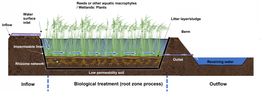
File:Constructed Wetland.png|thumb|1000px|The following is a labelled schematic of a constructed "Free-water surface flow wetland". These types of wetlands are generally used as a BMP for stormwater treatment and are most similar to stormwater management ponds, both in function and design, the major difference being that they are shallower to allow for wetland species (i.e. macrophytes to effectively grow and biologically treat incoming flows of pollutant and suspended sediments). <span style="color:red">''A note: The following is an "image map", feel free to explore the image with your cursor and click on highlighted labels that appear to take you to corresponding pages on the Wiki.''</span> | |||
rect 16 344 196 432 [[Inlets|Inlet]] | |||
rect 170 512 643 585 [[Inlets|Inlet]] | |||
rect 335 194 580 406 [[Inlets|Inlet]] | |||
poly 632 618 657 618 756 1086 727 1086 2532 1090 2704 607 2514 1075 752 1083 727 1097 [[Geotextiles|Impermeable Geotextile Liner]] | |||
rect 727 297 2583 908 [[Wetlands: Plants|Aquatic Plants]] | |||
rect 178 691 679 772 [[Geotextiles|Impermeable Geotextile Liner]] | |||
rect 727 889 2565 940 [[Wetlands|Sludge Layer]] | |||
rect 807 1108 2514 1192 [[Soil groups|Low Permeability Soil]] | |||
rect 2869 465 3052 556 [[Berms|Berm]] | |||
poly 2689 593 2616 849 3015 852 2829 603 [[Berms|Berm]] | |||
rect 2711 263 3206 336 [[Wetlands|Sludge Layer]] | |||
rect 1185 15 2195 168 [[Wetlands: Plants|Aquatic Plants]] | |||
rect 2609 849 3070 977 [[Flow control|Outlet Pipe]] | |||
rect 3078 900 3949 1039 [[Natural drainage|Receiving Waterbody]] | |||
</imagemap> | |||
{{TOClimit|2}} | |||
==Overview== | ==Overview== | ||
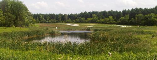
[[File:Kortright-farm-june-2011.jpg|thumb|500px|Wetlands fed by stormwater at Kortright Farm, Vaughan ON]] | |||
Free-water surface flow wetlands are most commonly employed for stormwater treatment and are similar to [[SWM ponds]] in function and design The most significant difference is the extent to which they are designed to incorporate shallow zones for wetland [[plants]]. A facility is normally characterized as a wetland if shallow zones (<0.5 m deep) make up more than 70 % of its volume. | |||
{{textbox|Wetlands are an ideal technology for: | {{textbox|Wetlands are an ideal technology for: | ||
* | *Enhancing biodiversity | ||
* | *Providing a more aesthetic aquatic landscape | ||
}} | }} | ||
Sub surface flow systems provide generally lower health and safety risks and are sometimes employed to handle stormwater in combination with another wastewater stream. | |||
==Planning considerations== | |||
{|class="wikitable" | {|class="wikitable" | ||
|+ Types of Constructed Wetland | |+ Types of Constructed Wetland<ref>Grant, N., M. Moodie, and C. Weedon. 2000. Sewage Treatment Solutions. p. 35–67. In Sewage Solutions: Answering the Call of Nature. Centre for Alternative Technology Publications.</ref><ref name="EPA">United States Environmental Protection Agency. 1995. A HANDBOOK OF CONSTRUCTED WETLANDS: A guide to creating wetlands for agricultural wastewater, domestic wastewater, coal mine drainage and stormwater.</ref><ref>Jacques Whitford Consultants, 2008. CONSTRUCTED & ENGINEERED WETLANDS p. 1-21</ref> | ||
|- | |- | ||
!Free-water surface flow | !Free-water surface flow | ||
| Line 16: | Line 58: | ||
!Vertical sub-surface flow | !Vertical sub-surface flow | ||
|- | |- | ||
|[[File:Schematic of the Free Water Surface Constructed Wetland.jpg|frameless| | |[[File:Schematic of the Free Water Surface Constructed Wetland.jpg|frameless|upright=1.5]] | ||
|[[File:Tilley et al 2014 Schematic of the Horizontal Subsurface Flow Constructed Wetland.jpg|frameless| | |[[File:Tilley et al 2014 Schematic of the Horizontal Subsurface Flow Constructed Wetland.jpg|frameless|upright=1.5]] | ||
|[[File:Tilley et al 2014 Schematic of the Vertical Flow Constructed Wetland.jpg|frameless| | |[[File:Tilley et al 2014 Schematic of the Vertical Flow Constructed Wetland.jpg|frameless|upright=1.5]] | ||
|- | |- | ||
| | |style="text-align:left;"|'''Pros''' | ||
*Robust | |||
*Provides excellent water quality treatment | |||
*Resistant to temporary hydraulic overload | |||
*Can be beautiful | |||
*Sludge removal infrequent | |||
|style="text-align:left;"|'''Pros''' | |||
*Well established technology | |||
*May be natural looking, although often rectilinear in plan | |||
*Need little to no gradient | |||
*Provides buffer to discharge | |||
*Good pathogen removal from die off and predation | |||
*Minimal maintenance | |||
*Wide range of [[Wetland: list|plants]] suitable | |||
*Robust | |||
|style="text-align:left;"|'''Pros''' | |||
*High levels of treatment possible | |||
*May be run without power if significant gradient is available | |||
*Can be attractively designed to generate interest in the technology, may be any shape. | |||
*Maintenance is technically simple. Sludge easily removed | |||
*Biologically complex and robust | |||
*Failure tends to be gradual | |||
*Will function prior to establishment of vegetation | |||
|- | |- | ||
| | |style="text-align:left;"|'''Cons''' | ||
|- | *Requires larger land area | ||
*Sludge removal may be more difficult | |||
*Open water may generate more health and safety concerns. | |||
|style="text-align:left;"|'''Cons''' | |||
*Requires more land | |||
*Multiple substrate layers will promote stratification and channelization | |||
|style="text-align:left;"|'''Cons''' | |||
*Requires fall of at least 1.5 m to provide sufficient treatment | |||
*May be high cost | |||
*Sensitive to hydraulic overloading | |||
|} | |} | ||
==Design== | ==Design== | ||
===Sizing free-water=== | |||
{| class="wikitable" | {| class="wikitable" | ||
|+Design parameters for free-water surface flow wetlands <ref name="TRCA">Toronto and Region Conservation Authority (TRCA), and CH2M Hill Canada. 2018. Inspection and Maintenance Guide for Stormwater Management Ponds and Constructed Wetlands (T van Seters, L Rocha, and K Delidjakovva, Eds.).</ref> | |||
!Element | !Element | ||
!Design Objective | !Design Objective | ||
| Line 41: | Line 109: | ||
|- | |- | ||
|Drainage Area | |Drainage Area | ||
|Sustaining vegetation, volumetric turnover | |Sustaining [[Plants|vegetation]], volumetric turnover | ||
|style="text-align: left|5 Ha (≥10 Ha preferred) | |style="text-align: left|5 Ha (≥10 Ha preferred) | ||
|- | |- | ||
|Treatment Volume | |Treatment Volume | ||
|Provision of appropriate level of protection | |Provision of appropriate level of protection | ||
|style="text-align: left|See | |style="text-align: left|See [[#.|below]] | ||
|- | |- | ||
|Active Storage | |Active Storage | ||
|Detention | |Detention | ||
|style="text-align: left|Suspended solids settling 24 hrs (12 hrs if in conflict with min. orifice size) | |style="text-align: left|[[Total Suspended solids|Suspended solids]] settling 24 hrs (12 hrs if in conflict with min. orifice size) | ||
|- | |- | ||
|Forebay | |Forebay | ||
|Pre-treatment | |Pre-treatment | ||
|style="text-align: left| | |style="text-align: left| | ||
*Minimum depth: 1 m; | |||
*Sized to ensure non-erosive velocities leaving forebay; | |||
*Maximum area: 20 % of total permanent pool | |||
|- | |- | ||
|Length-to-Width Ratio | |Length-to-Width Ratio | ||
|Maximize flow path and minimize short-circuiting potential | |Maximize flow path and minimize short-circuiting potential | ||
|style="text-align: left| | |style="text-align: left| | ||
*Overall: minimum 3:1; | |||
*Forebay: minimum 2:1 | |||
|- | |- | ||
|Permanent | |Permanent pool depth | ||
|Vegetation requirements, rapid settling | |Vegetation requirements, rapid settling | ||
|style="text-align: left|The average permanent pool depth should range from 150 mm to 300 mm | |style="text-align: left|The average permanent pool depth should range from 150 mm to 300 mm | ||
|- | |- | ||
|Active | |Active storage depth | ||
|Storage/flow control, sustaining vegetation | |Storage/flow control, sustaining vegetation | ||
|style="text-align: left|Maximum 1.0 m for storms < 10 year event | |style="text-align: left|Maximum 1.0 m for storms < 10 year event | ||
|- | |- | ||
|Side | |Side slopes (See also [[berms]]) | ||
|Safety | |Safety | ||
|style="text-align: left| | |style="text-align: left| | ||
*5:1 For 3 m above and below permanent pool; | |||
*Maximum 3:1 elsewhere | |||
|- | |- | ||
|Inlet | |Inlet | ||
|Avoid clogging/freezing | |Avoid clogging/freezing | ||
|style="text-align: left| | |style="text-align: left| | ||
*Minimum 450 mm; | |||
*Preferred pipe slope: > 1 %; | |||
*If submerged, obvert 150 mm below expected maximum ice depth | |||
|- | |- | ||
|Outlet | |Outlet (See also [[flow control]]) | ||
|Avoid clogging/freezing | |Avoid clogging/freezing | ||
|style="text-align: left| | |style="text-align: left| | ||
*Minimum: 450 mm outlet pipe; | |||
*Preferred pipe slope: > 1 %; | |||
*If orifice control used, 75 mm diameter minimum; | |||
*Minimum 100 mm orifice preferable | |||
|- | |- | ||
|Maintenance | |Maintenance access | ||
|Access for backhoes or dredging equipment | |Access for backhoes or dredging equipment | ||
|style="text-align: left| | |style="text-align: left| | ||
*Provided to approval of Municipality; | |||
*Provision of maintenance drawdown pipe preferred | |||
|- | |- | ||
|Buffer | |Buffer | ||
| Line 104: | Line 172: | ||
|style="text-align: left|Minimum 7.5 m above maximum water quality/erosion control water level | |style="text-align: left|Minimum 7.5 m above maximum water quality/erosion control water level | ||
|} | |} | ||
===.=== | |||
{| class="wikitable" | |||
|+Water volume storage requirements based on catchment type and receiving waters<ref name ="TRCA"/> | |||
!rowspan=2|Performance level | |||
!colspan=4|Storage volume (m<sup>3</sup>/Ha) required according to catchment impervious cover | |||
|- | |||
!35% | |||
!55% | |||
!70% | |||
!85% | |||
|- | |||
|80 % TSS removal||80||105||120||140 | |||
|- | |||
|70 % TSS removal||60||70||80||90 | |||
|- | |||
|60 % TSS removal||60||60||60||60 | |||
|} | |||
===Modeling sub-surface=== | |||
'''[http://www.unep.or.jp/Ietc/Publications/Water_Sanitation/SubWet2/index.asp SubWet 2.0]''' is a modeling tool for <u>sub-surface flow wetlands</u> (both 100% constructed and naturalized/adapted). It can be used to simulate removal of nitrogen (including nitrogen in ammonia, nitrate and organic matter), phosphorus and BOD<sub>5</sub> in mg/l and the corresponding removal efficiencies (in %). Although the model has been calibrated already with data from cold and warm climates, users can further calibrate and validate it using local data observations. | |||
==Materials== | |||
===Planting=== | |||
See [[Wetlands: Plants]] | |||
==Performance== | ==Performance== | ||
Relative to a wet pond, a constructed wetland may offer added pollutant removal benefits due to enhanced biological uptake and the filtration effects of the vegetation. | Relative to a wet pond, a constructed wetland may offer added pollutant removal benefits due to enhanced biological uptake and the filtration effects of the vegetation. | ||
Early stage wetlands readily sorb phosphorus onto substrates and sediments. Phosphorus removal in wetland systems is usually carried out by incorporating alum sedimentation ponds or [[sand filters]] as cells of the system, and/or by polishing wetland effluent in an iron-dosed mechanical filter.<ref>Jacques Whitford Consultants, 2008. CONSTRUCTED & ENGINEERED WETLANDS p. 1-21</ref> | |||
Freezing temperatures in winter and early spring can reduce treatment if the wetland either freezes solid or a cover of ice prevents the water from entering the wetland. If under-ice water becomes confined, water velocities may increase, thereby reducing contact times<ref name="EPA" />. Runoff in excess of maximum design flows should be [[Overflow#routing|diverted]] around the wetland to avoid excessive flows through the wetland. | |||
STEP (under previous name SWAMP) conducted their own research into the performance of stormwater wetlands, the project page and report can be viewed [https://sustainabletechnologies.ca/home/urban-runoff-green-infrastructure/conventional-stormwater-management/constructed-wetlands/performance-assessment-of-an-open-and-covered-stormwater-wetland-system-aurora-ontario/ here]. | STEP (under previous name SWAMP) conducted their own research into the performance of stormwater wetlands, the project page and report can be viewed [https://sustainabletechnologies.ca/home/urban-runoff-green-infrastructure/conventional-stormwater-management/constructed-wetlands/performance-assessment-of-an-open-and-covered-stormwater-wetland-system-aurora-ontario/ here]. | ||
Central Lake Ontario Conservation Authority have been undertaking a coastal wetland monitoring project across Durham region, see [https://www.cloca.com/lwc/monitoring_coastal.php here]. | |||
==Gallery== | ==Gallery== | ||
{{:Wetlands: Gallery}} | {{:Wetlands: Gallery}} | ||
==See also== | ==See also== | ||
*[[SWM ponds]] | *[[SWM ponds]] | ||
*[[Dry ponds]] | *[[Dry ponds]] | ||
*[[Plants]] | |||
==External links== | ==External links== | ||
[https://www.ontario.ca/page/wetland-conservation-strategy Ontario's wetland conservation strategy] | *[https://www.ontario.ca/page/wetland-conservation-strategy Ontario's wetland conservation strategy] | ||
Kennedy, G., and T. Mayer. 2002. Natural and Constructed Wetlands in Canada: An Overview. Water Qual. Res. J. Canada 37(2): 295–325. doi: 10.2166/wqrj.2002.020. | *[https://cawt.ca/ Centre for Advancement of Water and Wastewater Technologies at Fleming College] | ||
===Articles for review=== | |||
#Kennedy, G., and T. Mayer. 2002. Natural and Constructed Wetlands in Canada: An Overview. Water Qual. Res. J. Canada 37(2): 295–325. doi: 10.2166/wqrj.2002.020. | |||
#Bendoricchio, G., L. Dal Cin, and J. Persson. 2000. Guidelines for free water surface wetland design. EcoSys Bd 8: 51–91. http://www.pixelrauschen.de/wet/design.pdf (accessed 9 May 2018). | |||
---- | |||
Latest revision as of 21:02, 10 December 2021

Overview[edit]
Free-water surface flow wetlands are most commonly employed for stormwater treatment and are similar to SWM ponds in function and design The most significant difference is the extent to which they are designed to incorporate shallow zones for wetland plants. A facility is normally characterized as a wetland if shallow zones (<0.5 m deep) make up more than 70 % of its volume.
Wetlands are an ideal technology for:
- Enhancing biodiversity
- Providing a more aesthetic aquatic landscape
Sub surface flow systems provide generally lower health and safety risks and are sometimes employed to handle stormwater in combination with another wastewater stream.
Planning considerations[edit]
| Free-water surface flow | Horizontal sub-surface flow | Vertical sub-surface flow |
|---|---|---|

|

|

|
Pros
|
Pros
|
Pros
|
Cons
|
Cons
|
Cons
|
Design[edit]
Sizing free-water[edit]
| Element | Design Objective | Criteria |
|---|---|---|
| Drainage Area | Sustaining vegetation, volumetric turnover | 5 Ha (≥10 Ha preferred) |
| Treatment Volume | Provision of appropriate level of protection | See below |
| Active Storage | Detention | Suspended solids settling 24 hrs (12 hrs if in conflict with min. orifice size) |
| Forebay | Pre-treatment |
|
| Length-to-Width Ratio | Maximize flow path and minimize short-circuiting potential |
|
| Permanent pool depth | Vegetation requirements, rapid settling | The average permanent pool depth should range from 150 mm to 300 mm |
| Active storage depth | Storage/flow control, sustaining vegetation | Maximum 1.0 m for storms < 10 year event |
| Side slopes (See also berms) | Safety |
|
| Inlet | Avoid clogging/freezing |
|
| Outlet (See also flow control) | Avoid clogging/freezing |
|
| Maintenance access | Access for backhoes or dredging equipment |
|
| Buffer | Safety | Minimum 7.5 m above maximum water quality/erosion control water level |
.[edit]
| Performance level | Storage volume (m3/Ha) required according to catchment impervious cover | |||
|---|---|---|---|---|
| 35% | 55% | 70% | 85% | |
| 80 % TSS removal | 80 | 105 | 120 | 140 |
| 70 % TSS removal | 60 | 70 | 80 | 90 |
| 60 % TSS removal | 60 | 60 | 60 | 60 |
Modeling sub-surface[edit]
SubWet 2.0 is a modeling tool for sub-surface flow wetlands (both 100% constructed and naturalized/adapted). It can be used to simulate removal of nitrogen (including nitrogen in ammonia, nitrate and organic matter), phosphorus and BOD5 in mg/l and the corresponding removal efficiencies (in %). Although the model has been calibrated already with data from cold and warm climates, users can further calibrate and validate it using local data observations.
Materials[edit]
Planting[edit]
See Wetlands: Plants
Performance[edit]
Relative to a wet pond, a constructed wetland may offer added pollutant removal benefits due to enhanced biological uptake and the filtration effects of the vegetation. Early stage wetlands readily sorb phosphorus onto substrates and sediments. Phosphorus removal in wetland systems is usually carried out by incorporating alum sedimentation ponds or sand filters as cells of the system, and/or by polishing wetland effluent in an iron-dosed mechanical filter.[5]
Freezing temperatures in winter and early spring can reduce treatment if the wetland either freezes solid or a cover of ice prevents the water from entering the wetland. If under-ice water becomes confined, water velocities may increase, thereby reducing contact times[2]. Runoff in excess of maximum design flows should be diverted around the wetland to avoid excessive flows through the wetland.
STEP (under previous name SWAMP) conducted their own research into the performance of stormwater wetlands, the project page and report can be viewed here.
Central Lake Ontario Conservation Authority have been undertaking a coastal wetland monitoring project across Durham region, see here.
Gallery[edit]
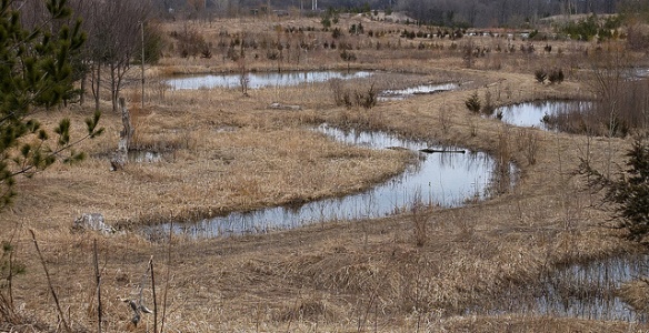
Emergent wetland vegetation supported by stormwater runoff at Kino Environmental Restoration Project. Photo by Matthew Grabau, US Fish and Wildlife Service
Azalea Park, Charlottesville VA - "This side of the park, formerly located along a runoff channel that led into Moore's Creek, has been converted into a wetland which supports a surprising amount of insect and amphibian life." -Credit and Photo: Scott Clark (certhia on Flickr).
See also[edit]
External links[edit]
- Ontario's wetland conservation strategy
- Centre for Advancement of Water and Wastewater Technologies at Fleming College
Articles for review[edit]
- Kennedy, G., and T. Mayer. 2002. Natural and Constructed Wetlands in Canada: An Overview. Water Qual. Res. J. Canada 37(2): 295–325. doi: 10.2166/wqrj.2002.020.
- Bendoricchio, G., L. Dal Cin, and J. Persson. 2000. Guidelines for free water surface wetland design. EcoSys Bd 8: 51–91. http://www.pixelrauschen.de/wet/design.pdf (accessed 9 May 2018).
- ↑ Grant, N., M. Moodie, and C. Weedon. 2000. Sewage Treatment Solutions. p. 35–67. In Sewage Solutions: Answering the Call of Nature. Centre for Alternative Technology Publications.
- ↑ 2.0 2.1 United States Environmental Protection Agency. 1995. A HANDBOOK OF CONSTRUCTED WETLANDS: A guide to creating wetlands for agricultural wastewater, domestic wastewater, coal mine drainage and stormwater.
- ↑ Jacques Whitford Consultants, 2008. CONSTRUCTED & ENGINEERED WETLANDS p. 1-21
- ↑ 4.0 4.1 Toronto and Region Conservation Authority (TRCA), and CH2M Hill Canada. 2018. Inspection and Maintenance Guide for Stormwater Management Ponds and Constructed Wetlands (T van Seters, L Rocha, and K Delidjakovva, Eds.).
- ↑ Jacques Whitford Consultants, 2008. CONSTRUCTED & ENGINEERED WETLANDS p. 1-21


