File:Credit River Concept.jpg

Original file (877 × 706 pixels, file size: 89 KB, MIME type: image/jpeg)
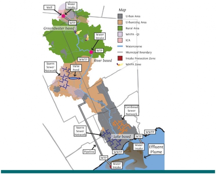
A conceptual image depicting a Lake Ontario watershed demonstrates that the watershed scale reveals the connections between different water management activities, and their reliance on shared water resources. The figure depicts a scenario where storm sewers discharge directly to streams and lakes without treatment, and areas where ponds treat stormwater prior to discharge. The figure shows drinking water sourced from groundwater, riverine and lake sources, as well as a pipeline to transport the water to upper reaches within the watershed. Lastly, river-based and lake-based wastewater discharge – including from combined sewers – is also shown. (Source: CVC).
File history
Click on a date/time to view the file as it appeared at that time.
| Date/Time | Thumbnail | Dimensions | User | Comment | |
|---|---|---|---|---|---|
| current | 21:14, 17 September 2017 |  | 877 × 706 (89 KB) | BillyTLID (talk | contribs) | A conceptual image depicting a Lake Ontario watershed demonstrates that the watershed scale reveals the connections between different water management activities, and their reliance on shared water resources. The figure depicts a scenario where storm s... |
You cannot overwrite this file.
File usage
The following page uses this file: