Uncategorized files
Jump to navigation
Jump to search
Showing below up to 500 results in range #501 to #1,000.
View (previous 500 | next 500) (20 | 50 | 100 | 250 | 500)
 Infiltration trenches et al final.pdf ; 14.92 MB
 Influent Effluent EMT.PNG 1,070 × 813; 354 KB
 Inlet - clogged - Elm Drive.JPG 4,240 × 2,384; 9.91 MB
 Inlet Miss rd.jpg 3,120 × 4,160; 2.24 MB
 Inlet Obstruction Fail swale.PNG 557 × 398; 511 KB
 Inlet Obstruction Pass swale.PNG 542 × 394; 461 KB
 Inlet Pass p.p.JPG 408 × 286; 28 KB
 Inlet cond grass fail.JPG 638 × 426; 81 KB
 Inlet cond grass pass.JPG 626 × 424; 56 KB
 Inlet flow grass fail.JPG 815 × 585; 116 KB
 Inlet flow grass pass.JPG 810 × 586; 67 KB
 Inlet to bioswale - Wychwood.JPG 4,240 × 2,384; 10.19 MB
 Inlets Fail RWH.PNG 627 × 475; 389 KB
 Inlets Pass RWH.PNG 638 × 476; 710 KB
 Inlets bio fail.PNG 646 × 428; 678 KB
 Inlets bio pass.PNG 565 × 418; 712 KB
 Inlets fail underground.PNG 703 × 526; 709 KB
 Inlets pass underground.PNG 699 × 532; 770 KB
 Institutional Options.png 1,055 × 592; 620 KB
 Integrating LID stormwater asset management pic.PNG 1,181 × 412; 73 KB
 Interevent times.PNG 969 × 668; 207 KB
 Jar test.jpg 1,394 × 597; 124 KB
 Jen.JPG 2,437 × 1,625; 1.77 MB
 Jet cleaning.jpg 650 × 355; 37 KB
 JointCutting1.jpg 380 × 214; 35 KB
 JointCutting2.jpg 477 × 248; 55 KB
 Juncus effusus stmacrinacoop.jpeg 500 × 335; 159 KB
 Juncus tenuis Cahen.jpeg 1,024 × 768; 222 KB
 Kane-porous.jpg 318 × 422; 32 KB
 Karstification.PNG 1,397 × 859; 2.59 MB
 Kenollie Rain Garden.jpeg 2,448 × 3,264; 3.39 MB
 Kenollie Rain Garden.jpg 1,056 × 792; 350 KB
 Kenollie rain garden after maintenance.jpg 3,264 × 2,448; 3.88 MB
 Kenollie rain garden after maintenance2.jpg 3,264 × 2,448; 3.54 MB
 Key Design and Plan Review Considerations Schematic.png 2,348 × 4,300; 379 KB
 Kitchener-8.jpg 500 × 375; 35 KB
 Kocsis two tanks in ground.jpg 480 × 640; 156 KB
 Kortright-farm-june-2011.jpg 1,400 × 535; 360 KB
 Kortright Planting Plan.PNG 1,327 × 869; 737 KB
 Kortright parking.jpg 845 × 755; 453 KB
 Kortright trench.PNG 1,147 × 850; 1.53 MB
 Kortright trench update.png 3,340 × 2,475; 11.96 MB
 Kyle Vander Linden.jpg 864 × 1,050; 152 KB
 LCCT 25mm Retention Full.png 3,909 × 2,835; 141 KB
 LCCT 25mm Retention No infiltration.png 3,911 × 2,838; 141 KB
 LCCT 25mm Retention Partial infiltration.png 3,911 × 2,838; 154 KB
 LCCT Tool 2021.PNG 728 × 659; 68 KB
 LCCtool.PNG 536 × 668; 108 KB
- LID-IM-Guide-2016-1.pdf ; 32.26 MB
- LID-IM-Guide-2016-1.pdf RWH.pdf ; 168 KB
- LID-IM-Guide-7.6-Green-Roofs.pdf ; 134 KB
 LID-IM small.jpg 563 × 422; 154 KB
 LIDTTT.png 1,367 × 767; 879 KB
 LID BMPUpdate.png 1,651 × 231; 1,001 KB
 LID BMP ex. Updated.png 4,422 × 1,049; 6.52 MB
 LID BMP ex.png 1,873 × 248; 1.32 MB
 LID Fact Sheet-button.PNG 1,750 × 171; 13 KB
 LID Facts 2.png 1,652 × 230; 976 KB
 LID Salt reduction.png 3,902 × 1,527; 183 KB
 LID TTT.png 145 × 75; 4 KB
 LID options for light industrial sites.png 1,054 × 593; 432 KB
- LID poster - Green Roof final.pdf ; 15.47 MB
- LID poster - PICP - vfinal.pdf ; 4.71 MB
- LID poster - bioretention - vfinal2.pdf ; 8.79 MB
 LSRCA curb.jpg 448 × 336; 42 KB
 LSRCA planters.jpg 4,160 × 3,120; 3.93 MB
- LSRCA salt workshop results.pdf ; 1.81 MB
 LSRCAlogo.png 225 × 225; 10 KB
 Lake Ontario 2012.png 648 × 504; 477 KB
 Lake Ontario Drought 2007.png 466 × 348; 323 KB
 Lake detection green roof.PNG 511 × 738; 825 KB
 Lakeside - green roof 1.JPG 4,240 × 2,384; 11.13 MB
 Lakeside - permeable concrete 1.JPG 4,240 × 2,384; 7.34 MB
 Lakeside - sheet flow parking lot 1.JPG 4,240 × 2,384; 10.22 MB
 Lakeview Grass Swale, curb cut inlet.JPG 4,608 × 3,456; 5.96 MB
 Lakeview Grass Swale, poured concrete inlet.JPG 4,000 × 3,000; 4.79 MB
 Lakeview bioretention swale with native species.jpg 4,608 × 3,456; 6.21 MB
 Lakeview mississauga.PNG 494 × 808; 71 KB
 Lakeview residential bioretention swale.jpg 4,608 × 3,456; 6.26 MB
 Lakeview swale curb cut during a rain event.jpg 4,608 × 3,456; 6.57 MB
 Landforms of a place of worship.JPG 831 × 361; 131 KB
 Landforms of a school.JPG 830 × 364; 127 KB
 Large Commercial Options.png 1,057 × 594; 533 KB
 Large bioretention Meadows in the Glen .JPG 4,608 × 3,456; 6.07 MB
 Layers green roof.PNG 701 × 810; 663 KB
 Leaf Screens.jpg 561 × 818; 73 KB
 Leak detection green roof.PNG 511 × 733; 823 KB
 Legal tool first nations.PNG 721 × 831; 152 KB
 Level of service.PNG 187 × 792; 9 KB
 Levelspread.jpg 298 × 168; 21 KB
 Life cycle cost all variations RWH.PNG 1,418 × 752; 180 KB
 Life cycle cost estimate green roof.PNG 683 × 621; 84 KB
 Life cycle cost for all variations.PNG 1,422 × 768; 189 KB
 Life cycle costs.PNG 829 × 613; 87 KB
 Life cycle costs RWH.PNG 794 × 695; 100 KB
 Life cycle costs swales.PNG 1,216 × 695; 171 KB
 Life cycle estimate p.p.JPG 678 × 508; 70 KB
 Liftable trench.jpg 2,448 × 3,264; 2.52 MB
 Lifting paver to clean.JPG 1,552 × 867; 242 KB
 Liner-roadside.jpg 4,032 × 3,024; 6.04 MB
 Local Industrial Road Cross Section.png 977 × 613; 337 KB
 Local Residential Road Rural Cross-section.png 1,152 × 648; 258 KB
 Local Residential Road Urban Cross-section.png 997 × 614; 285 KB
 Low Rise Options.png 1,055 × 591; 354 KB
 MAINTENANCE.jpg 1,500 × 476; 223 KB
 MLSmith swale.jpg 569 × 600; 234 KB
- MOECC on LID 2015.pdf ; 108 KB
 Main-Street-Markham-Markham-ON-03-1200x640.jpg 1,200 × 640; 157 KB
 Main Streets Cross Section.png 977 × 597; 293 KB
 MaintenancePICP.png 1,430 × 1,073; 2.98 MB
 Maintenance & operation p.p.JPG 664 × 512; 82 KB
 Maintenance and Operation green roofs.PNG 679 × 485; 71 KB
 Maintenance of plants green roof.PNG 460 × 776; 751 KB
 Maintenance of treetrench.PNG 636 × 333; 610 KB
 Major Arterial Cross Section.png 978 × 605; 367 KB
 Mariotte Guelph.jpg 427 × 835; 29 KB
- Matusik 2004.pdf ; 1.63 MB
 Meadows in the Glen PP sidewalk and driveway bibs .jpg 4,608 × 3,456; 6.16 MB
 Measuring friction LSRCA office.png 1,840 × 1,285; 4.44 MB
 Med FC SNAP Our Lady of Fatima Rain Garden planting 20220603 (56).JPG 4,032 × 3,024; 7.81 MB
 Media hand.jpg 1,728 × 3,072; 1.48 MB
 Millgroup green roof.PNG 813 × 555; 537 KB
 Mini&high freq green roof.PNG 1,195 × 721; 183 KB
 Minimum & hig hfreq cost p.p.PNG 1,230 × 689; 191 KB
 Minimum & hig hfrequency costs.pp.JPG 1,212 × 677; 143 KB
 Minimum high fre cost underground.PNG 1,019 × 552; 115 KB
 Minor Arterial Road Cross Section.png 977 × 607; 322 KB
 Mississauga - Central Parkway - silva cell installation.JPG 2,816 × 2,112; 1.43 MB
 Mississauga Rd.gif 400 × 400; 39.01 MB
 Mississauga Road - Brampton - curb cuts.JPG 4,240 × 2,384; 6.88 MB
 Modified Philip Dunne.PNG 542 × 682; 630 KB
 Monitor Fail p.p.JPG 623 × 423; 34 KB
 Monitor Pass p.p.JPG 634 × 424; 77 KB
 Monitoring-well-subgrade.jpg 4,000 × 3,000; 4.53 MB
 MonitoringWell bio fail.PNG 833 × 567; 1.04 MB
 MonitoringWell bio pass.PNG 842 × 562; 1.25 MB
 Monitoring well.gif 478 × 512; 29 KB
 Monitoring well chamber.PNG 328 × 381; 197 KB
 Monitoring well fail underground.PNG 497 × 364; 546 KB
 Monitoring well pass underground.PNG 481 × 361; 523 KB
 Muhlenbergia mexicana.jpg 500 × 375; 165 KB
 Multi-barrier-safe-drinking-water-co.jpg 740 × 869; 129 KB
 Native Child.jpg 960 × 720; 383 KB
 Natural Ground Cover.png 902 × 692; 398 KB
 New York Bumpout.PNG 1,199 × 750; 687 KB
 Newly developed swale.PNG 456 × 700; 858 KB
 North Dakota State U infiltration trench.jpg 300 × 400; 28 KB
 OGS types Lee, 2014.PNG 329 × 383; 49 KB
 OGS types Lee, 2014 update.PNG 485 × 563; 94 KB
 OLF Rain Garden.jpg 4,032 × 3,024; 7.81 MB
 ORMGP.JPG 1,073 × 615; 90 KB
 O Connor Park maintenance and monitoring site inspection.JPG 5,184 × 3,456; 6.44 MB
 O connor Park Bioretention.JPG 3,456 × 4,608; 5.29 MB
 Outfall TTT.png 170 × 81; 5 KB
 Outlet & overflow pass underground.PNG 496 × 353; 252 KB
 Outlet covered swale.PNG 712 × 738; 1.58 MB
 Outlets Fail RWH.PNG 607 × 455; 685 KB
 Outlets Pass RWH.PNG 606 × 455; 510 KB
 Overflow-outlet Miss Road.jpg 4,160 × 3,120; 5.55 MB
 Overflow-pipe-install.jpg 4,000 × 3,000; 4.37 MB
 Overflow-plastic-cap.jpg 2,816 × 2,112; 1.4 MB
 OverflowEdge.png 461 × 371; 207 KB
 Overflow - Elm Drive.JPG 4,240 × 2,384; 8.56 MB
 Overflow Fail p.p.JPG 601 × 443; 66 KB
 Overflow Outlet Fail swale.PNG 580 × 389; 616 KB
 Overflow Outlet Pass swale.PNG 571 × 382; 534 KB
 Overflow Pass p.p.JPG 594 × 450; 64 KB
 Overflow bio fail.PNG 830 × 566; 1.39 MB
 Overflow bio pass.PNG 845 × 560; 1.2 MB
 Overground RHW.jpg 1,536 × 2,048; 1.12 MB
 P.P.png 872 × 100; 9 KB
 P.P Pic.png 874 × 335; 501 KB
 P.p plan and profile view.PNG 548 × 807; 644 KB
 P1000154.JPG 4,000 × 3,000; 5.58 MB
 P1090179 SlingerTruck.JPG 2,816 × 2,112; 1.37 MB
 P1120709.JPG 2,816 × 2,112; 1.42 MB
 P1150948.JPG 2,816 × 2,112; 1.42 MB
 P1160102.JPG 2,816 × 2,112; 1.45 MB
 P1160117.JPG 2,816 × 2,112; 1.47 MB
 P1160121.JPG 2,816 × 2,112; 1.52 MB
 P1160129.JPG 2,816 × 2,112; 1.37 MB
 P7270012 550x550.jpg 550 × 550; 93 KB
 PEP Design Kempen RWH.PNG 752 × 620; 929 KB
 PICPDouble.png 1,430 × 1,073; 3.19 MB
 PICPchicago.jpg 1,200 × 1,600; 409 KB
 PP IWS.gif 579 × 453; 484 KB
 PSD sand.jpg 857 × 534; 57 KB
 PSD sand.png 858 × 533; 31 KB
 Parking-lot-infiltration-chamber.JPG 859 × 648; 124 KB
 Parthenocissus quinquefolia.jpeg 500 × 375; 198 KB
 Partial infiltration.png 1,191 × 1,043; 455 KB
 Partial with storage.png 1,166 × 1,029; 456 KB
 Particle permeability.png 856 × 539; 20 KB
 Particle void ratio.png 759 × 542; 20 KB
 Pass.PNG 620 × 415; 702 KB
 Pass Filter Bed green roof.PNG 695 × 494; 852 KB
 Pass Veg green roof.PNG 748 × 494; 1.02 MB
 Pass irrigation system green roof.PNG 725 × 512; 949 KB
 Pass overflow green roof.PNG 706 × 494; 1,006 KB
 Pass perimeter green roof.PNG 732 × 543; 797 KB
 Pass protective layers green roof.PNG 704 × 530; 909 KB
 PaveDrain.jpg 4,160 × 3,120; 2.99 MB
 PavementwithBioretention.png 549 × 447; 571 KB
 PavementwithTrees.png 585 × 441; 673 KB
 Paver-cutting-incorrect.JPG 2,816 × 2,112; 1 MB
 Paver-placement-crane.JPG 640 × 480; 84 KB
 Paver-placement-cut.JPG 2,816 × 2,112; 1.49 MB
 Paver-placement-vehicle-2.JPG 1,600 × 1,200; 1.05 MB
 Paver-placement-vehicle.JPG 2,816 × 2,112; 1.46 MB
 Pavesurface Fail p.p.JPG 612 × 469; 64 KB
 Pavesurface Pass p.p.JPG 655 × 489; 75 KB
 Pearson Graph.png 1,118 × 590; 58 KB
 Per-task cost estimate swale.PNG 670 × 732; 95 KB
 Perc test.png 668 × 1,012; 674 KB
 Perc test.xlsx ; 20 KB
 Perf concrete van.jpg 3,264 × 2,448; 2.02 MB
 Perf pipe.gif 1,200 × 672; 4.26 MB
 Perf pipe.gif resize.gif 1,200 × 672; 54 KB
 Perf pipe resize small.gif 417 × 194; 1.99 MB
 Perforated Pipe 550x550.jpg 550 × 550; 43 KB
 Perforated concrete block alt.jpg 3,264 × 2,448; 1.22 MB
 Perforated pipe grass swale system diagram.png 375 × 290; 216 KB
 Perforations.png 1,055 × 573; 434 KB
 Perimeter Fail swale.PNG 541 × 405; 481 KB
 Perimeter Pass swale.PNG 544 × 406; 606 KB
 Perimeter bio fail.PNG 572 × 430; 715 KB
 Perimeter bio pass.PNG 587 × 433; 734 KB
 Perimeter grass fail.JPG 617 × 422; 44 KB
 Perimeter grass pass.JPG 612 × 421; 45 KB
 Permanent-fencing.jpg 5,184 × 3,456; 9.99 MB
 Perme pavement banner.JPG 1,218 × 578; 156 KB
 Permeabel paver plan.PNG 1,516 × 623; 205 KB
 PermeablePavementConstruction.jpg 1,173 × 880; 320 KB
 PermeablePaving CS.png 730 × 823; 553 KB
 PermeablePaving CrossSection.png 735 × 811; 553 KB
 Permeable Driveway.JPG 4,272 × 2,848; 5.46 MB
- Permeable Pavement Factsheet.pdf ; 4.71 MB
 Permeable paver profile.PNG 1,521 × 571; 301 KB
 Permeameter.png 180 × 931; 30 KB
 PerviousConcreteConstruction.jpg 3,648 × 2,736; 4.29 MB
 PerviousConcretePrecast.png 696 × 524; 857 KB
 Perviousconcrete.png 516 × 359; 382 KB
 PhilJames.jpg 2,396 × 1,892; 724 KB
 Picture1.jpg 976 × 585; 65 KB
 Picture for page.PNG 353 × 727; 799 KB
 Pipe with connector.jpg 3,120 × 3,120; 2.86 MB
 Plan & profile view Infilt underground.PNG 642 × 849; 716 KB
 Plantain boromir.jpeg 1,024 × 683; 279 KB
 Planter.png 1,185 × 986; 451 KB
 Planter PWD.jpg 640 × 428; 233 KB
 Planting CVC Janet I McDougald.JPG 4,032 × 3,024; 5.28 MB
 Planting Plan.PNG 729 × 863; 499 KB
 Planting on green roof.jpg 400 × 287; 58 KB
 Plastic PP.jpg 2,432 × 3,286; 3.12 MB
 Plastic grid paving.jpg 4,160 × 3,120; 5.67 MB
 Pollution hot spots.jpg 1,328 × 530; 258 KB
 PondRd1.jpg 2,592 × 1,936; 2.96 MB
 PondRd2.jpg 2,413 × 1,819; 2.98 MB
 Pond curves.png 1,039 × 372; 29 KB
 PorousAsphaltParkingLot.png 261 × 195; 84 KB
 PorousAsphalt Stalls.png 2,592 × 1,936; 7.28 MB
 Porous asphalt.jpg 4,160 × 3,120; 5.8 MB
 Porousasphalt.png 549 × 411; 450 KB
 Portico Church water level monitoring.JPG 5,184 × 3,456; 7.21 MB
 Precast drywell.jpg 640 × 480; 164 KB
 Pretreat Fail p.p.JPG 2,560 × 1,920; 389 KB
 Pretreat Fail swale.PNG 590 × 410; 519 KB
 Pretreat Pass p.p.JPG 500 × 667; 156 KB
 Pretreat Pass swale.PNG 584 × 410; 532 KB
 Pretreatment Fail RWH.PNG 598 × 424; 565 KB
 Pretreatment Pass RWH.PNG 592 × 426; 457 KB
 Pretreatment downspout RWH.PNG 489 × 615; 641 KB
 Pretreatment fail bio.PNG 612 × 436; 834 KB
 Pretreatment inlet Fail underground.PNG 701 × 496; 943 KB
 Pretreatment inlet pass underground.PNG 692 × 488; 833 KB
 Pretreatment pass bio.PNG 626 × 424; 734 KB
 Protecting swale durign construction.PNG 1,082 × 633; 756 KB
 Pump Fail RWH.jpg 800 × 400; 45 KB
 Pump Pass RWH.PNG 848 × 634; 1.05 MB
 Queen Lane2.jpeg 640 × 428; 270 KB
 RAINWATER HARVESTING TANK 550x550.jpg 550 × 550; 175 KB
 RS18728 LIDwiki6-lpr.jpg 2,000 × 1,333; 1.61 MB
 RS3969 080-04 Greenwood stream restoration2.jpg 2,832 × 2,128; 2.23 MB
 RS7349 IMG 1409.JPG 5,184 × 3,456; 11.01 MB
 RWH.gif 1,280 × 720; 9.8 MB
 RWH.png 867 × 330; 527 KB
- RWH DC TOOL v.1.4.xlsm ; 8.35 MB
 RWH Tree.PNG 1,262 × 708; 142 KB
 RWH Update.gif 1,280 × 720; 9.8 MB
 RWH and trees.jpg 640 × 441; 134 KB
- RWH final.pdf ; 2.24 MB
 RWH rain barrel.PNG 337 × 614; 530 KB
 RWH system planview.PNG 854 × 737; 240 KB
 RWH tank capacity table.jpg 1,556 × 709; 504 KB
 Radar tracking August 2012.png 598 × 369; 562 KB
 RainBarrel.jpg 900 × 1,200; 167 KB
 Rain Garden Schematic.png 1,056 × 942; 377 KB
 Rain Garden in Victoria crop.jpg 648 × 308; 141 KB
 Rain Garden plan.PNG 978 × 863; 179 KB
 Rain Garden profile.PNG 1,588 × 853; 365 KB
 Rain garden.png 747 × 1,296; 1.46 MB
 Rainwater cistern opening title.PNG 1,267 × 599; 1.51 MB
 Rainwater harvesting plan.PNG 1,252 × 859; 196 KB
 Rainwater harvesting profile.PNG 1,129 × 542; 186 KB
 Rainwatercistern cross.PNG 705 × 673; 169 KB
 Red Drain.jpg 2,592 × 1,936; 4.6 MB
 Required inspections and maintenance.PNG 828 × 564; 90 KB
 ResidentialPICP.png 1,430 × 1,073; 3.16 MB
 Residential Collector Cross Section.png 979 × 618; 344 KB
 Residential soakaway plan.PNG 1,418 × 867; 257 KB
 Residential soakaway profile.PNG 1,233 × 859; 323 KB
 Residential swale1.JPG 4,272 × 2,848; 6 MB
 Residential swale2.JPG 4,272 × 2,848; 4.81 MB
 Residential swale3.JPG 4,272 × 2,848; 5.09 MB
- Ribbon Test.pdf ; 25 KB
 Riparian veg stream.jpg 2,989 × 1,971; 1.45 MB
 Riser.gif 600 × 384; 2.44 MB
 Riversides sideyard infiltration trench 1.jpg 226 × 245; 22 KB
 Rock pad energy dissipator.PNG 482 × 364; 518 KB
 Roof-Leader-Set-Up-v1.PNG 720 × 960; 64 KB
 Roof Drain.jpg 1,518 × 2,072; 1.06 MB
 Rooftop-Treatment-System-v2.png 720 × 478; 40 KB
 Rooftop-Treatment-System-v3.PNG 720 × 477; 43 KB
 Rooftop-Treatment-System v1.PNG 720 × 960; 43 KB
 Rose Hasner Rain barrel.jpg 1,704 × 2,272; 716 KB
 Rouge Wetlands.jpg 640 × 329; 195 KB
 Routing.png 833 × 631; 35 KB
 SPZ signage.jpg 576 × 864; 475 KB
 STEP MONITORING.jpg 1,240 × 661; 330 KB
 STEP Minto Cistern P1 - Copy.jpg 1,495 × 981; 284 KB
 STEP cropped.jpg 586 × 412; 132 KB
 STEP logo.png 656 × 149; 39 KB
 SWM Arches.jpg 841 × 473; 50 KB
 SWM Crates.jpg 840 × 473; 41 KB
 SWM Pipe.jpg 841 × 473; 52 KB
 SWM Vaults.jpg 841 × 473; 39 KB
 SWM sheep.jpg 3,456 × 4,608; 1.67 MB
 SWTT High Perm Soil Cells Final.png 2,079 × 3,741; 7.89 MB
 SWTT Low Perm Soil Cells Final.png 2,064 × 3,741; 7.9 MB
 SWTT Struct Pan High Perm Final.png 2,333 × 3,696; 6.89 MB
 SWTT Struct Pan High Perm Final crop.png 2,059 × 3,696; 5.6 MB
 SWTT Struct Soil Med High Perm Final.png 2,053 × 3,741; 7.65 MB
 Salt by catchbasin.PNG 856 × 467; 958 KB
 Salt comparison.PNG 701 × 858; 197 KB
 Sand accumulated road.PNG 441 × 780; 642 KB
 Sandy Bioretention Soil Mix.jpg 2,448 × 3,264; 2 MB
 Scarification.JPG 4,032 × 3,024; 7.46 MB
 Schematic infitlration trench (Jeon et al., 2022).PNG 972 × 708; 350 KB
 Scirpus atrovirens.jpeg 1,024 × 683; 359 KB
 Scirpus cyperinus jheiser.jpg 1,024 × 859; 360 KB
 Scour-fabric.jpg 242 × 209; 12 KB
 Screeningprocessdiagram.png 962 × 1,257; 44 KB
 Secch idisk.PNG 611 × 504; 338 KB
- Section 4 Handouts.pdf ; 12.19 MB
 Sections perimeters.png 814 × 528; 15 KB
 Sediment accumulation perm.JPG 629 × 538; 79 KB
 Sediment removal.PNG 846 × 517; 913 KB
 SedumrollGR.JPG 2,560 × 1,920; 1.1 MB
 Shade ball coverage esker.PNG 1,360 × 821; 2.5 MB
 Shade balls brampton.jpg 1,430 × 1,073; 286 KB
 Shade balls close up.jpg 687 × 515; 55 KB
 Shallow monitoring well.png 3,017 × 2,277; 5.02 MB
 Shutterstock 94975348+resized.jpg 350 × 232; 51 KB
 Simon Bunn.PNG 1,072 × 1,013; 2 MB
 Simulated storm event.PNG 781 × 578; 1.14 MB
 Simulated storm event in a swale.PNG 556 × 370; 638 KB
 Single ring infilt p.p.PNG 631 × 754; 1.17 MB
 Site Conditions ROW.jpg 1,024 × 768; 877 KB
 Site Conditions ROW2.jpg 1,024 × 768; 905 KB
 Site Conditions Road Right of Way Cover.jpg 1,024 × 768; 746 KB
 Site design.png 1,003 × 378; 718 KB
 Sizing Bioretention.jpg 1,277 × 1,025; 190 KB
 Sizing bio1.png 919 × 499; 408 KB
 Sizing bio2.png 530 × 449; 177 KB
 Sizing calculator.PNG 1,141 × 215; 18 KB
 Sizing flow-through planter.jpg 1,341 × 1,030; 171 KB
 Small Commercial Sites Options.png 1,056 × 595; 453 KB
 Smart about salt training.PNG 407 × 412; 229 KB
 Smart drain.jpg 2,448 × 2,068; 671 KB
 Snow filter strip.png 393 × 260; 272 KB
 Snow piles.jpg 4,608 × 3,456; 2.11 MB
 Soakaway monitorign well.PNG 414 × 583; 762 KB
 Soakaways infiltration et.al.png 1,652 × 373; 1.17 MB
 Soil Cell Plan View.PNG 1,300 × 832; 221 KB
 Soil Cell Profile View.PNG 1,006 × 449; 145 KB
 Soil bulk density figure 8.7.PNG 1,057 × 805; 576 KB
- Error creating thumbnail: File missingSoil cells - construction.PNG 857 × 420; 1.08 MB
 Soil testing indicators.PNG 867 × 443; 194 KB
 Solid splashpad.jpg 1,000 × 664; 395 KB
 Sorptive media.jpg 4,608 × 3,456; 2.67 MB
 Source Jennifer Rosales tree bumpout.jpg 700 × 522; 124 KB
 Source Protection Atlas tool.PNG 1,363 × 910; 1.62 MB
 Source Protection regions map.PNG 1,128 × 857; 418 KB
 Spill containgment site - pre construction - Mississauga.JPG 2,816 × 2,112; 1.46 MB
 Spill containment structure - Mississauga.JPG 2,816 × 2,112; 1.48 MB
 Sporobolus michauxianus.jpeg 500 × 375; 199 KB
 Spot8 p2 20190820.JPG 4,032 × 3,024; 5.02 MB
 Spray-Irrigation.jpg 800 × 571; 209 KB
 Square Grid.png 271 × 241; 2 KB
 St-patricks-parade-8-1024.jpg 550 × 550; 133 KB
 Staff testing.PNG 808 × 551; 1.34 MB
 Stepped cells.png 1,229 × 884; 635 KB
 Stockpile in gutter.jpg 4,032 × 3,024; 3.97 MB
 Stone in ponding zone.jpg 1,024 × 768; 390 KB
 Storage TTT.png 177 × 78; 5 KB
 Storm bmps rev3.png 502 × 447; 226 KB
 Storm drain protection.PNG 506 × 289; 377 KB
 Stormwater Planter Updated.png 2,043 × 3,098; 5.12 MB
- Error creating thumbnail: File missingStormwater Planter Updated compacted.png 2,055 × 3,277; 5.96 MB
 Stormwater Tree Trench Structural Panel Soil Cell.png 2,109 × 3,508; 7.7 MB
 Stormwater Tree Trench high permeability native subsoil with soil cells.png 2,006 × 3,444; 7.97 MB
 Stormwater Tree Trench high permeability native subsoil with structural soil medium.png 1,928 × 3,444; 7.64 MB
 Stormwater Tree Trench low permeability native subsoil with structural soil medium.png 1,928 × 3,421; 7.66 MB
- Error creating thumbnail: File missingStormwater Tree Trenches at East Bayfront Promenade, Toronto.jpg 1,024 × 768; 338 KB
 Stormwater planter.png 951 × 1,408; 1.19 MB
 Stormwater planter pu.png 1,284 × 966; 1.59 MB
 Sub TTT.png 212 × 76; 13 KB
 Subsurface draw outlet.PNG 1,051 × 640; 326 KB
 Subsurface outlet depth.png 900 × 336; 53 KB
 Sump inelt to chamber system.JPG 819 × 534; 60 KB
 Surface ponding Fail Swale.PNG 552 × 394; 579 KB
 Surface ponding Pass Swale.PNG 790 × 495; 1.09 MB
 Sustainability Planning Roadmap.jpg 699 × 406; 56 KB
 Swale TTT.png 158 × 77; 6 KB
 Swale sections.PNG 1,967 × 1,434; 899 KB
- Swales final.pdf ; 1.59 MB
- Swales final Update.pdf ; 1.59 MB
- Swales inspection sheet.pdf ; 226 KB
 T-junction photo.jpg 218 × 163; 19 KB
 TBG2005.jpg 619 × 285; 93 KB
 TBG2014.jpg 1,068 × 405; 191 KB
 TD Bank.jpg 2,144 × 885; 848 KB
- TO curb.pdf ; 708 KB
 TP.PNG 920 × 819; 83 KB
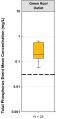 TP - green roof.JPG 454 × 885; 88 KB
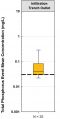 TP - infiltration trench.JPG 445 × 885; 90 KB
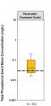 TP - permeable pavement.JPG 473 × 986; 99 KB
 TP - rainwater harvesting.JPG 438 × 885; 87 KB
 TP effluent comparison.PNG 1,337 × 740; 163 KB
 TRCA YorkU grass swale 3.jpg 1,600 × 1,200; 943 KB
 TRCA water balance tool.PNG 759 × 465; 722 KB
 TSS - OGS out.JPG 450 × 885; 85 KB
 TSS - green roof.JPG 451 × 885; 85 KB
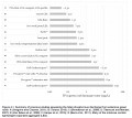
 TSS - infiltration trench.JPG 448 × 885; 90 KB
 TSS - permeable pavement.JPG 447 × 885; 93 KB
 TSS - rainwater harvesting.JPG 441 × 885; 86 KB
 TSS Inlet.jpg 453 × 885; 32 KB
 TSS effluent comparison.PNG 1,340 × 714; 177 KB
 TTT.png 855 × 107; 30 KB
 TTT menu.PNG 88 × 658; 38 KB
 Tamping.jpg 624 × 416; 110 KB
 Task Cost estimates.PNG 645 × 639; 109 KB
 Task cost estimates p.p.JPG 657 × 493; 70 KB
 Task cost underground.PNG 663 × 286; 40 KB
 Temp. depth pond.png 1,024 × 382; 147 KB
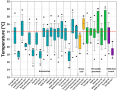
 Temporal changes (5-yr median) 1966 - 2022.jpg 2,550 × 1,650; 1.08 MB
 Tension infilt data log.PNG 564 × 611; 903 KB
- Test2.pdf ; 12 KB
 Test pit.jpg 1,236 × 773; 72 KB
 Thermal load reduction LID.PNG 1,072 × 740; 297 KB
 Theta.jpg 849 × 359; 21 KB
- Thornthwaite1957.pdf ; 9.75 MB
 Thunder Bay and Toronto.png 928 × 766; 39 KB
 Time & cost estimates underground.PNG 682 × 488; 75 KB
 Time commit cost.PNG 873 × 676; 110 KB
 Time commit cost swale.PNG 906 × 683; 111 KB
 Time commit costs RWH.PNG 767 × 428; 55 KB
- Tiner 2014.pdf ; 2.88 MB
 Topsoil depth.jpg 560 × 420; 75 KB
 Toronto Botanical Garden Jen.jpg 4,608 × 3,456; 4.91 MB
 Treatment train air force.JPG 1,296 × 294; 73 KB
 Treatmenttrain TRCA.JPG 738 × 479; 54 KB
 TreeTranspiration.png 591 × 712; 157 KB
 Tree trench.PNG 495 × 377; 76 KB
- Tree trenches 2022.pdf ; 1.22 MB
- Tree trenches final.pdf ; 2.28 MB
- Tree trenches final Update.pdf ; 570 KB
 Treetrench.png 1,043 × 331; 579 KB
 Trenchdrain.JPG 3,888 × 2,592; 4.26 MB
 Trimble unit.JPG 4,032 × 3,024; 7.8 MB
 Two prong method catchbasin sediment acc..PNG 508 × 618; 71 KB
 Typical underground RWH.jpg 1,338 × 671; 133 KB
 U.g.rwh2.png 1,037 × 942; 819 KB
- USFHWA 2009.pdf ; 6.48 MB
 U of Guelph supersize rainbarrel.png 258 × 386; 142 KB
 U of Guelph underground cistern.png 363 × 365; 237 KB
 Underdrain-subgrade.jpg 4,000 × 3,000; 4.65 MB
 Underdrain-with-risers.jpg 4,000 × 3,000; 4.52 MB
 Underdrain Fail p.p.JPG 615 × 426; 43 KB


.JPG)


.PNG)


_1966_-_2022.jpg)


