Inspection and Maintenance: Enhanced Swales
Overview[edit]
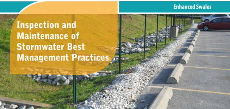
Enhanced swales are gently sloping vegetated open channels featuring a parabolic or trapezoidal cross-section and check dams, designed to convey and treat stormwater runoff (i.e., rainwater or snowmelt from roofs or pavements). The grading, Check dams and vegetation spreads out and slows down the flow of water, allowing suspended sediment and floatables (e.g., trash, natural debris, oil and grease) to settle out. A portion of the flowing water soaks into the soil and replenishes groundwater or is taken up by plant roots and evaporated back to the atmosphere. Runoff water is delivered to the practice through inlets such as curb cuts, spillways or other concrete structures, sheet flow from pavement edges, or pipes connected to catchbasins or roof downspouts. The planting bed and side slopes are typically covered with grasses or a mixture of flood tolerant, erosion resistant vegetation and stone. They do not feature filter media soil and sub-drains like bioretention or bioswales do. Water not ponded behind check dams or absorbed by the planting bed is conveyed to an adjacent drainage system (e.g., municipal storm sewer or other BMP) at the lowest downstream point by an outlet structure (e.g., ditch inlet catchbasin, culvert). Key components of this feature are described in further detail below.
Properly functioning enhanced swales reduce the quantity of pollutants and runoff being discharged to municipal storm sewers and receiving waters (i.e., rivers, lakes and wetlands). In addition to their SWM benefits, enhanced swales provide aesthetic value as attractive landscaped features.
Key components of Enhanced swales to pay close attention to are the:
Trash, debris and sediment builds up at these locations and can prevent water from flowing into or out of the practice.
Associated Practices[edit]
- Grass Swales: A parabolic or trapezoidal-sized bottom, swale that contains grassed sloping sides and a filter media bottom to both convey overland flow and provide water treatment, and are often subject to more frequent maintenance. They generally contain an outlet structure at the lowest point for water to be sent to another LID BMP or the storm system; sometimes referred to as a roadside ditch. Does not contain check dams.
- Swales: Swales are linear landscape features consisting of a drainage channel with gently sloping sides. Underground they may be filled with engineered soil and/or contain a water storage layer of coarse gravel material. Two variations on a basic swale are recommended as low impact development strategies, although using a combination of both designs may increase the benefit.
- Bioswales are sometimes referred to as 'dry swales', 'vegetated swales', or 'water quality swales'. This type of BMP is form of bioretention with a long, linear shape (surface area typically >2:1 length:width) and a slope which conveys water and generally contains various water tolerant vegetation
Inspection and Testing Framework[edit]

Component |
Indicators |
Construction Inspection |
Assumption Inspection |
Routine Operation Inspection |
Verification Inspection |
|---|---|---|---|---|---|
| Contributing Drainage Area | |||||
| CDA condition | x | x | x | x | |
| Inlet | |||||
| Inlet/Flow Spreader Structural Integrity | x | x | x | ||
| Inlet/Flow Spreader Structural Integrity | x | x | x | x | |
| Pretreatment sediment accumulation | x | x | x | ||
| Inlet erosion | x | x | |||
| Perimeter | |||||
| BMP dimensions | x | x | x | ||
| Side slope erosion | x | x | |||
| Surface ponding area | x | x | x | ||
| Filter Bed | |||||
| Standing water | x | x | x | ||
| Trash | x | x | |||
| Filter bed erosion | x | x | |||
| Filter bed sediment accumulation | x | x | x | ||
| Surface ponding depth | x | x | x | ||
| Filter bed surface sinking | x | x | x | ||
| Check dams | x | x | x | x | |
| Planting Area | |||||
| Vegetation cover | x | x | x | x | |
| Vegetation condition | x | x | |||
| Vegetation composition | x | x | x | ||
| Outlet | |||||
| Overflow outlet obstruction | x | x | x | x |

Component |
Indicators |
Construction Inspection |
Assumption Inspection |
Routine Operation Inspection |
Verification Inspection | |
|---|---|---|---|---|---|---|
| Testing Indicators | ||||||
| Soil characterization testing | x | x | (x) | |||
| Sediment accumulation testing | x | x | x | x | ||
| Surface infiltration rate testing | x | (x) | ||||
| Natural or simulated storm event testing | x | (x) | ||||
| Note: (x) denotes indicators to be used for Performance Verification inspections only (i.e., not for Maintenance Verification inspections) | ||||||
- ↑ TRCA. 2016. Fact Sheet - Inspection and Maintenance of Stormwater Best Management Practices: Enhanced Swales. https://sustainabletechnologies.ca/app/uploads/2018/02/Enhanced-Swales-Fact-Sheet.pdf
- ↑ STEP. 2016. Low Impact Development Stormwater Management Practice Inspection and Maintenance Guide. https://sustainabletechnologies.ca/app/uploads/2016/08/LID-IM-Guide-2016-1.pdf
- ↑ STEP. 2016. Low Impact Development Stormwater Management Practice Inspection and Maintenance Guide. https://sustainabletechnologies.ca/app/uploads/2016/08/LID-IM-Guide-2016-1.pdf